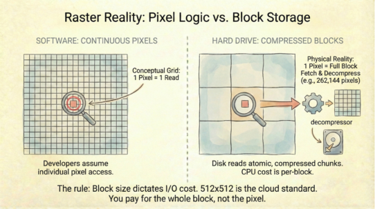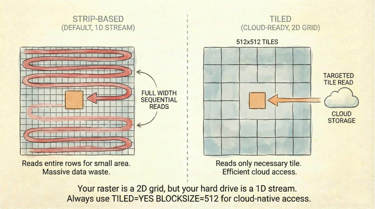
Strip-based GeoTIFFs are the default. They’re also terrible for web maps. Tiling fixes this by reorganizing pixels into independent blocks, but only if you explicitly enable it.
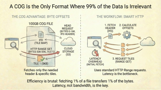
A standard TIFF stores pixels in long horizontal strips row after row. To read a 10×10 pixel box in the center of a 50,000-pixel-wide image, you must decode the full width of every row involved. That’s 50,000 × 10 = 500,000 pixels decoded to access 100. Massive waste.
Tiling breaks the image into independent square blocks—typically 512×512 pixels. To read that same 10×10 box, you fetch and decompress only the single tile containing it. The rest of the file stays on disk. Latency drops exponentially.
Each tile is a self-contained compression block. Corruption in one tile doesn’t cascade through the file. A missing tile is recoverable. Strip-based files lack this isolation corruption can ripple across rows.
Tiling is the prerequisite for cloud-native access. HTTP range requests depend on knowing “I need bytes 10,000–15,000 and those bytes form a coherent geographic area.” Strips don’t guarantee this. Tiles do.
GDAL defaults to strips. You must explicitly set TILED=YES and BLOCKSIZE=512. Block size matters: 256 creates too many HTTP requests; 1024 fetches too much unused data. 512 is the sweet spot.
Tiling adds minor file size overhead (padding), but the CPU cost during reads drops dramatically.
The rule: Always explicitly set TILED=YES BLOCKSIZE=512. Never assume the default is cloud-ready. Strips are for sequential processing. Tiles are for the internet.
Whenever you’re ready, here are 4 ways I can help you grow in GIS & spatial data:
Spatial Lab – My private community where GIS professionals, data engineers, and analysts connect, swap workflows, and build repeatable systems together.
Modern GIS Accelerator – A guided program to help you break out of legacy GIS habits and learn modern, scalable workflows.
Career Compass – A career-focused program designed to help GIS pros navigate the job market, sharpen their pitch, and find roles beyond traditional GIS paths.
Sponsorship: Interested in sponsoring this newsletter (or other content)? Learn more here and fill out the form to get in touch!