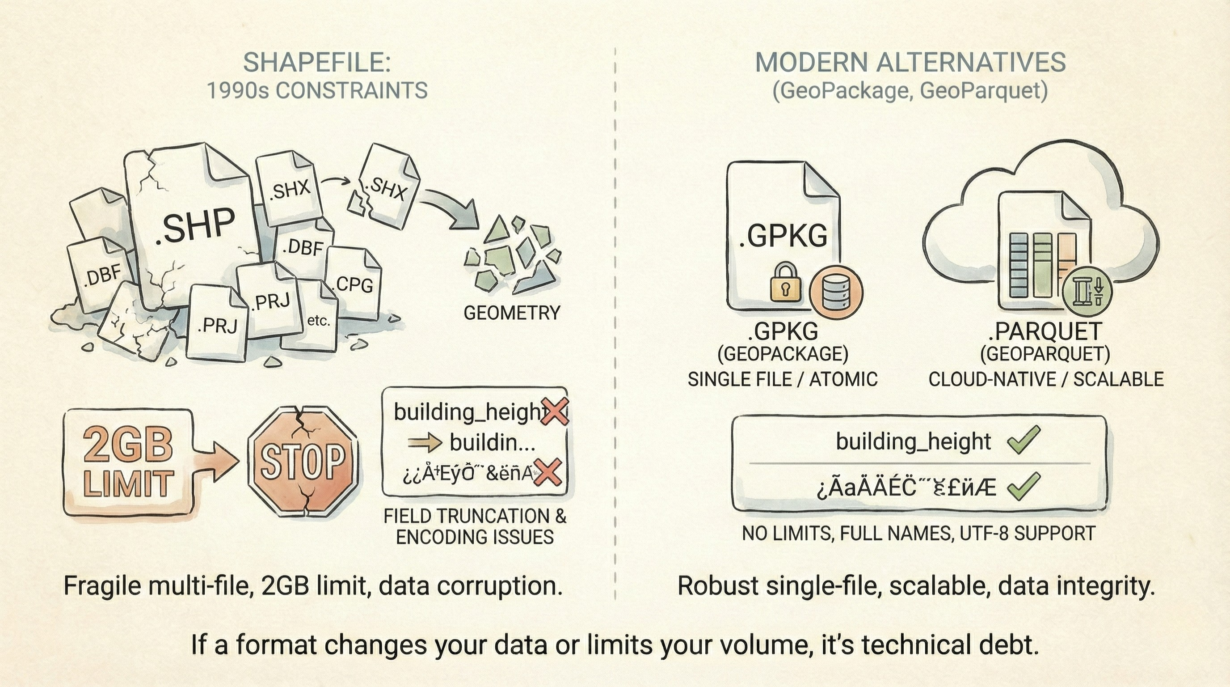
Stop storing data in Shapefiles. They’re not just outdated—they actively corrupt your data and break automation at scale.
A “Shapefile” isn’t one file. It’s 3-8 separate files (.shp, .shx, .dbf, .prj, .cpg, etc.). Lose the .shx index file, and your geometry is unreadable. Move files to cloud storage without keeping them paired, and they’re useless. This multi-file dependency breaks atomic operations. Versioning becomes a nightmare. A single file format solves this entirely.
The .dbf attribute table (dBASE IV from 1989) truncates field names to 10 characters. “building_height” becomes “building_h.” Longer names silently disappear. Worse: DBF can’t distinguish between zero and NULL—common values merge. Your integrity is already compromised.
The 2GB size limit is a hard physical constraint. 32-bit file offsets cap the format there. A dataset larger than 2GB must be manually split across multiple files. That’s not a feature. That’s a failure.
Character encoding issues persist. Shapefiles don’t reliably store UTF-8. Non-ASCII characters corrupt. Archives break predictably across systems.
Use GeoPackage (SQLite-based, single file, proper transactions, no field truncation) for local work and inter-team exchange. Use GeoParquet (columnar, cloud-native, schema enforcement, compression) for analytics and data lakes. Both solve what Shapefiles break.
The rule: If a format changes your data (truncation) or limits your volume (2GB), it’s not storage—it’s technical debt.
Whenever you’re ready, here are 4 ways I can help you grow in GIS & spatial data:
Spatial Lab – My private community where GIS professionals, data engineers, and analysts connect, swap workflows, and build repeatable systems together.
Modern GIS Accelerator – A guided program to help you break out of legacy GIS habits and learn modern, scalable workflows.
Career Compass – A career-focused program designed to help GIS pros navigate the job market, sharpen their pitch, and find roles beyond traditional GIS paths.
Sponsorship: Interested in sponsoring this newsletter (or other content)? Learn more here and fill out the form to get in touch!