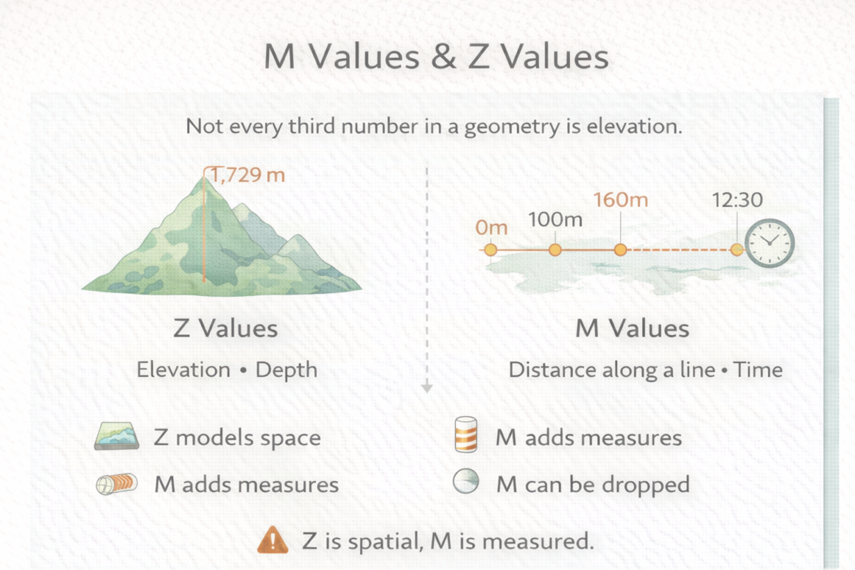
Most GIS tools silently drop M values because people confuse them with Z. They’re not interchangeable. Losing M values breaks linear referencing and event-based analysis.
Standard geometry has X and Y—horizontal location. Z values add a third spatial dimension: elevation, depth, altitude. A point becomes 3D. A line becomes a path through space. Z is spatial. It affects where features actually sit relative to gravity and visual space.
M values add a measured dimension: distance along a line, time, or any continuous value. M is not spatial—it’s metadata attached to geometry. A road centerline with M values lets you say “event at 2.3 km from start.” A GPS track with M as time lets you say “vehicle at this location at 3:45pm.” M enables linear referencing and temporal queries.
The confusion happens because both are “extra” dimensions. But Z changes geometry interpretation. M adds measurement context. Tools that don’t understand M often discard it silently. You load a shapefile with M values, export it to GeoJSON, and M is gone. The geometry looks the same. But your linear referencing breaks.
3D geometry (Z values) requires explicit handling. Not all rendering, indexing, or analysis supports it. Many operations assume 2D. Upgrading to 3D adds overhead without value unless you actually need elevation in your analysis.
The rule: Z is where (spatial). M is how far or when (measured). Use M for roads with mileposts, streams with elevation profiles, or time-series data. Don’t discard M without thinking. Use Z only if elevation or depth matters to your analysis. Check if your tools even preserve it before investing in 3D workflows.
Whenever you’re ready, here are 4 ways I can help you grow in GIS & spatial data:
Spatial Lab – My private community where GIS professionals, data engineers, and analysts connect, swap workflows, and build repeatable systems together.
Modern GIS Accelerator – A guided program to help you break out of legacy GIS habits and learn modern, scalable workflows.
Career Compass – A career-focused program designed to help GIS pros navigate the job market, sharpen their pitch, and find roles beyond traditional GIS paths.
Sponsorship: Interested in sponsoring this newsletter (or other content)? Learn more here and fill out the form to get in touch!