Most people treat quadkeys as optional formatting. They’re actually a different way to think about tile location—one that simplifies storage and indexing at scale.
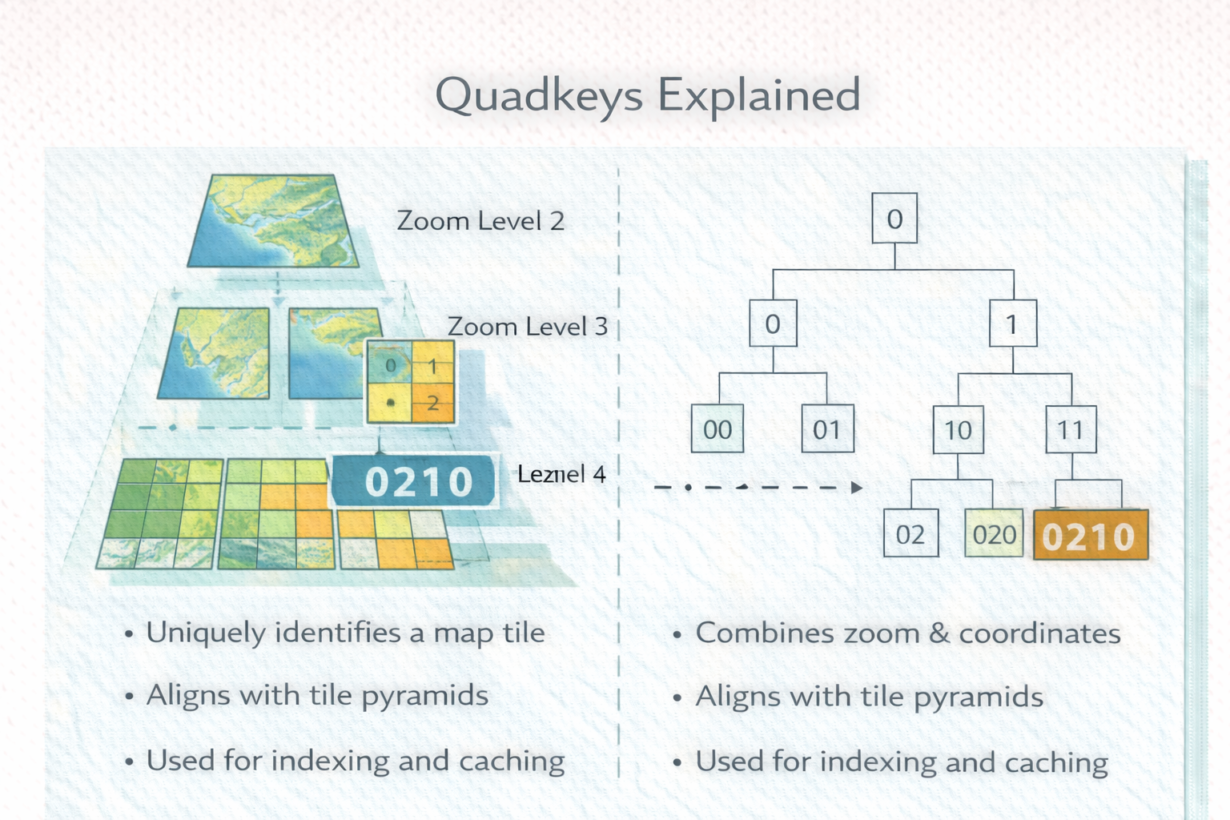
A quadkey is a string that uniquely identifies a map tile. Instead of referencing a tile by zoom level, X coordinate, and Y coordinate (z/x/y format), a quadkey encodes all three into one hierarchical string.
Here’s how it works: start with the whole world at zoom 0 (quadkey “”—empty string). Subdivide into 4 tiles at zoom 1: “0”, “1”, “2”, “3” (north-west, north-east, south-west, south-east). Each of those subdivides into 4 more at zoom 2: “00”, “01”, “02”, “03”, “10”, “11”, etc. The pattern is recursive. A quadkey “0213” means: zoom level 4, then subdivisions 0→2→1→3 from the root down.
Why this matters: quadkeys encode hierarchy naturally. A longer quadkey is always a child of a shorter one. “021” contains “0213” and “0214”. This creates a tree structure that’s perfect for caching, indexing, and distributed storage.
Tile z/x/y coordinates don’t have this property. You can’t tell if one tile contains another by looking at their coordinates alone.
Most cloud storage systems and tile servers use quadkeys internally. They’re searchable, sortable, and enable prefix-based indexing. Query “all tiles starting with ’02′” and you get an entire region.
The rule: Quadkeys simplify large-scale tile systems. If you’re building tile infrastructure or need to reason about tile hierarchies, use quadkeys. If you’re just requesting tiles from a standard map API, the addressing is invisible. But if you’re storing, indexing, or caching millions of tiles, quadkeys outperform flat z/x/y schemes.
Whenever you’re ready, here are 4 ways I can help you grow in GIS & spatial data:
Spatial Lab – My private community where GIS professionals, data engineers, and analysts connect, swap workflows, and build repeatable systems together.
Modern GIS Accelerator – A guided program to help you break out of legacy GIS habits and learn modern, scalable workflows.
Career Compass – A career-focused program designed to help GIS pros navigate the job market, sharpen their pitch, and find roles beyond traditional GIS paths.
Sponsorship: Interested in sponsoring this newsletter (or other content)? Learn more here and fill out the form to get in touch!