Most GIS people conflate features, geometry, and records. This confusion breaks joins, corrupts data, and creates impossible bugs.
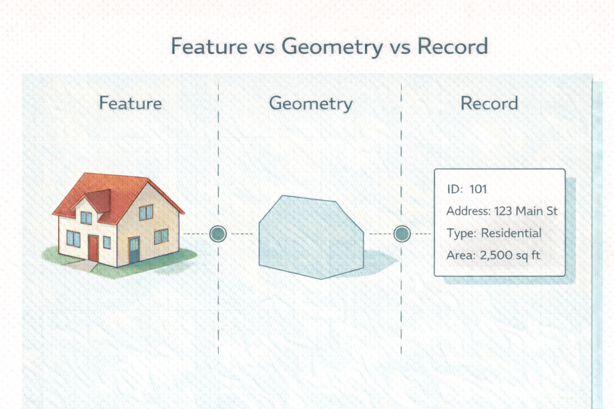
A feature is a real-world object: a building, a road, a parcel. An ID (like 12345) represents it uniquely.
Geometry is the spatial shape: a polygon, a linestring, a point. Feature 12345 has a polygon as its geometry.
A record is the row of attributes: address, owner, zoning, acreage. Feature 12345 has these attributes in a record.
Modern GIS systems store these separately and link them by ID. You can have geometry without a matching record (orphaned shapes). You can have records without geometry (imported addresses without coordinates). Both are problems, but they’re different problems.
Here’s why this matters: a spatial join creates new records based on spatial relationships. It doesn’t change geometry. Join a buildings layer to a zoning layer on geometry overlap, and you get new records linking building attributes to zone attributes. The original building geometry is untouched.
Conversely, a record change (address update, owner change) doesn’t touch geometry. The building shape stays the same. Only the record changes.
The mistake: people delete or edit records thinking it’s a spatial operation, or they try to fix spatial problems by editing records. ID mismatches emerge. Joins mysteriously fail.
The rule: IDs link features to records and geometry. Keep IDs consistent. Joins operate on records and IDs, not geometry. Geometry is separate. Records change often. Geometry changes rarely. Treat them as distinct.
Whenever you’re ready, here are 4 ways I can help you grow in GIS & spatial data:
Spatial Lab – My private community where GIS professionals, data engineers, and analysts connect, swap workflows, and build repeatable systems together.
Modern GIS Accelerator – A guided program to help you break out of legacy GIS habits and learn modern, scalable workflows.
Career Compass – A career-focused program designed to help GIS pros navigate the job market, sharpen their pitch, and find roles beyond traditional GIS paths.
Sponsorship: Interested in sponsoring this newsletter (or other content)? Learn more here and fill out the form to get in touch!