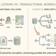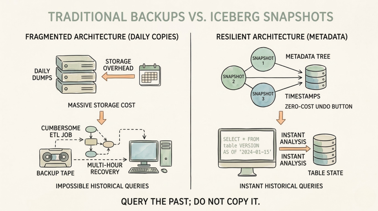
Most organizations manage spatial data history by dumping daily Shapefiles to archive storage. Massive overhead. Impossible to query. Iceberg’s time travel replaces this with metadata snapshots—instant historical queries without copying a single file.
Iceberg snapshots are metadata, not data. Every transaction creates a new snapshot that points to the current state of the table. Snapshot 1: 10 million features. Tomorrow, you add 100,000 features and update 50,000. Snapshot 2 points to the new state. The underlying files aren’t duplicated. The metadata tree records “what existed at timestamp X.”
Query historical data instantly: SELECT * FROM table VERSION AS OF '2024-01-15'. Iceberg reads from the snapshot taken on that date, using the exact file references that existed then. No restore job. No multi-hour recovery. Metadata operation.
Compare to traditional backups: daily Shapefile dumps create redundant copies of 100GB datasets. After 2 years, you’ve spent petabytes on storage. Querying across snapshots requires custom ETL. With Iceberg, you query across all history with the same SQL.
Retention policies control storage cost. Snapshots older than 30 days are “vacuumed” (removing orphaned files). Balance audit needs against storage budget. Most use 90-day retention.
Debugging spatial pipelines becomes trivial. A geometry update script broke today. Query the dataset as it was yesterday, compare geometries, identify the bug. Time travel turns hours of investigation into minutes.
The rule: Query the past; don’t copy it. Snapshots are your zero-cost undo button. If comparing historical geometries requires an ETL job, you need a table format.
Whenever you’re ready, here are 4 ways I can help you grow in GIS & spatial data:
Spatial Lab – My private community where GIS professionals, data engineers, and analysts connect, swap workflows, and build repeatable systems together.
Modern GIS Accelerator – A guided program to help you break out of legacy GIS habits and learn modern, scalable workflows.
Career Compass – A career-focused program designed to help GIS pros navigate the job market, sharpen their pitch, and find roles beyond traditional GIS paths.
Sponsorship: Interested in sponsoring this newsletter (or other content)? Learn more here and fill out the form to get in touch!