Most people think of GIS as drawing and clicking. Raster analysis is different. It’s math applied to millions of cells simultaneously.
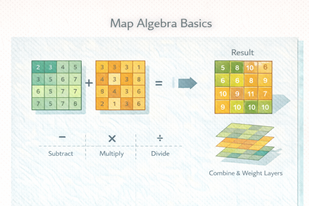
Map algebra is applying mathematical operations to every cell in a raster (or multiple rasters). A raster is a grid. Each cell has a value. Map algebra does arithmetic on cells: add elevation + slope, multiply suitability scores, threshold temperature above 30°C. Every cell gets calculated independently.
Here’s a concrete example: you have three rasters—distance to roads, elevation, and vegetation density. You want to find suitable locations for solar farms. Multiply distance-to-roads by 0.3 (weight), add elevation0.2, add vegetation0.5. Now every cell has a suitability score. Do this with vectors? You’d dissolve, overlay, intersect—operations that slow down with data size. With rasters, you calculate every cell once. Speed doesn’t degrade.
This is why map algebra scales. It’s embarrassingly parallel. Process 10,000 cells? Same code as 1 billion cells. Distributed systems run it across clusters without coordination overhead.
Map algebra is fundamental to environmental modeling, risk assessment, and suitability analysis. Any problem that’s “find locations where condition A AND condition B AND condition C apply” maps directly to raster math.
The difference from vector: vector overlays combine discrete features. Raster math treats continuous surfaces. Different tools for different data types.
The rule: If you’re analyzing continuous surfaces or large-area conditions, think raster. Write simple math expressions. Let the system parallelize. Vector operations are powerful for features. Raster operations are powerful for fields. Use the right one. Map algebra scales where vector breaks.
Whenever you’re ready, here are 4 ways I can help you grow in GIS & spatial data:
Spatial Lab – My private community where GIS professionals, data engineers, and analysts connect, swap workflows, and build repeatable systems together.
Modern GIS Accelerator – A guided program to help you break out of legacy GIS habits and learn modern, scalable workflows.
Career Compass – A career-focused program designed to help GIS pros navigate the job market, sharpen their pitch, and find roles beyond traditional GIS paths.
Sponsorship: Interested in sponsoring this newsletter (or other content)? Learn more here and fill out the form to get in touch!